Sør-Odal municipality wants the town of Skarnes to promote good health and become more inclusive and attractive.
Through good planning of common areas in the town centre, a project should contribute to increasing activity in the population by stimulating more cycling and walking and reducing social exclusion through the correct localization of social meeting places.
A more pedestrian-friendly town
The municipality has plans for the development of, among other things, housing for the elderly and houses for families, and then they will also facilitate a transition from a very car-oriented to a more pedestrian-friendly town.
To visualize the possibilities, the municipality invited the specialists in urban analysis and smart mobility from OsloMet, to come up with interesting scenarios for how this can be solved.
The scenarios were also to be stress-tested for heavy loads, for example when it comes to traffic.
“Because we are urban planners, architects and geographers, we can form an interdisciplinary team that can contribute to society and help to solve real-world problems,” says Professor Claudia van der Laag at OsloMet.
The interaction of streets and land use affects public health
The aim was to look at the connection between public health, streets, and land use, and how to create environments that stimulate increased activity and inclusion.
“Together with GIS manager Kay Henning Kleverud from Sør-Odal municipality, we organized a workshop for 21 participants from nine municipalities, where we outlined visions, ideas, facilities, and street networks for how Skarnes can develop.”
“Then we modelled their ideas with computer tools and saw how these scenarios could work in the urban space, socially and economically, so that we could stress test them.”
“What kind of tools did you use?”
Space syntax affects human behaviour
“We used what we call a space syntax approach, or we can also call it a socio-spatial and socio-economic analytical technique for mathematical street network modelling.”
Space syntax is a theoretical and methodological approach in urban planning and design that focuses on the understanding of street network patterns and their impact on human behaviour, social interactions and economic activity.
Space Syntax is used to study, for example, the way urban layouts affect pedestrian movement, traffic flow and social interaction.
Sensors provide a data basis
The use of sensor technology can provide a good database. Sensors that record, for example, traffic volumes, can provide a real picture of how the areas are used today.
“And this is about giving space to people so that they can be active and do different things in the town of Skarnes?”
“Yes, and it is done to get an idea of what the potential is, for example for pedestrian movement, and how one can navigate and orient oneself through the town as an urban system, and how the morphology, or shape and structure, of this can be.”
It should be easier to move
“We emphasize that how the city is developed can create a coherent whole, so that people can move easily, navigate easily on foot, and that it should be pedestrian-friendly, and that they should also be able to cycle.
Important issues were ensuring a safe route to school, contributing to less driving for children to school, stimulating cycling or public transport, reducing social exclusion with the universal design of meeting places, less motorized traffic, and provision for the elderly.
Safety and accessibility
The participants in the workshop's biggest concern was safety, and how people can walk safely both day and night.
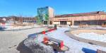
One of the major challenges Skarnes has is that it is very car-oriented, accidents occasionally happen, and it is often difficult for pedestrians to cross large streets.
“I think one of the challenges is the river in the middle, and that the settlement is divided in two, and the connection to many homes is connected by a car bridge and a footbridge.”
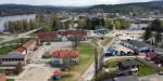
Roundabouts and bridges create challenges for residents of Skarnes who want to be active and get around in the local environment. Photo: Private
Quick analyses of different scenarios
“I found that the analyses were interesting for the participants in the workshop and that they were very surprised at how quickly we were able to assess how the solutions worked in the scenarios.”
“They already had a finished master plan for how they want to develop in the future, but they still had thoughts of going beyond this, and developing further scenarios.”
“They were surprised and engaged by how well the method we offered from OsloMet worked, and how easily the planning interventions could be assessed.”
“We gave them the results, the analysis results and the model, and they put it in their development project report, which will be published after the summer holidays.”
“What kind of specific problems did you become aware of?”
“Roundabouts, for example. They had a roundabout for cars, and this became a big challenge when you must move around as a pedestrian and get over to the footbridge over the river.”
“This roundabout destroys the connection to the footbridge, and the more walkable areas, says Claudia Hedwig van der Laag.
Other problems are uneven use of areas and a pedestrian tunnel that is not particularly pedestrian-friendly, especially at night.
Important for further work
Kay Henning Kleverud from Sør-Odal municipality emphasizes that it was incredibly exciting and value-creating for the project to be able to bring together different fields of expertise to solve the same tasks.
“Everyone contributed, and OsloMet's contribution was an important key to getting the project done and everyone learned something new,” he says.
“The results of the workshop are important for the further work on the project, but also for the nine municipalities that participated to bring new knowledge into their own organisation,” says Kay Henning Kleverud.
The workshop helps to see value in the project by having worked with the data, and not just looking at the data to get an overview, he believes.
More about transport and urban planning at OsloMet.